Uncheck JOSM Default style!
| Mode | Key | Description | Explanation |
|---|---|---|---|
| access=* | General access | Key to describe a general access restriction that applies to all transport modes. | |
| vehicle=* | Vehicle | Any vehicle. NL:RVV voertuigen: fietsen, bromfietsen, gehandicaptenvoertuigen, motorvoertuigen, trams en wagens. |
|
| foot=* | Foot | Pedestrians NL:RVV Voetgangers. |
|
| bicycle=* | Bicycle | Cyclists NL: "de fiets" fietsen, het vervoermiddel. |
|
| mofa=* | Mofa | "Low performance moped", usually with a maximum design speed of 25 km/h. NL:RVV snorfiets: 1. bromfiets die blijkens de gegevens in het kentekenregister is geconstrueerd voor een maximumsnelheid die niet meer bedraagt dan 25 km per uur, met uitzondering van de speed-pedelec, of 2. bromfiets als bedoeld in artikel 1, eerste lid, onderdeel e, subonderdeel d, van de wet |
|
| moped=* | Moped | Motorized bicycles with a speed restriction; e.g., at most a 50 cc engine or max. speed of about 45 km/h. NL:WvW bromfiets: artikel 1, eerste lid, onderdeel e, onder a, b en c, van de wet; | |
| horse=* | Horse | The horse (animal) or/and the combination with a rider. | |
| dog=* | Dog | Dog. | |
| dog=leashed | Dog leashed | Access_sign explains that the dogs must be leashed. | |
| dog=unleashed | Dog unleashed | Access_sign explains that the dogs can walk free. | |
| dog=under_control | Dog under control | Access_sign explains that the dogs must be under control, if not, dog is not allowed unleashed. | |
| carriage=* | Carriage | Horse(s) and carriage. | |
| motor_vehicle=* | Motor_vehicle | Any motorized vehicle, common mistake, this is also moped and mofa! | |
| motorcycle=* | Motorcycle | A 2-wheeled motor vehicle, allowed to drive on motorways. NL:RVV motorfiets: motorvoertuig op twee wielen al dan niet met zijspan- of aanhangwagen. |
motorcar=* | Motorcar | Automobiles/cars NL:RVV personenauto: personenauto als bedoeld in artikel 1.1 van de Regeling voertuigen. |
| hgv=* | Hgv | heavy goods vehicle; e.g., goods vehicles with a maximum allowed mass over 3.5 tonnes. NL:RVV vrachtauto: motorvoertuig, niet ingericht voor het vervoer van personen, waarvan de toegestane maximum massa meer bedraagt dan 3500 kg. |
|
| agricultural=* | Agricultural | Agricultural motor vehicles; e.g., tractors) that have additional restrictions; e.g., a 25 km/h speed limit. | |
| bus=* | Bus | A heavy bus acting as a public service vehicle. NL:RVV autobus: motorvoertuig, ingericht voor het vervoer van meer dan acht personen, de bestuurder daaronder niet begrepen. |
|
| psv=* | Psv | Public service vehicle. | |
| atv=* | Atv | Atv a.k.a. Quad (bike) (Restricted to or permissive for vehicles 50 in, 1.27 m, or less in width) still in proposal stage. | |
| snowmobile=* | Snowmobile | All kind of snowmobiles. | |
| double_tracked_motor_vehicle=* | Motor_vehicle double tracked | Motor vehicles with more than 2 wheels/more than 1 track. NL:RVV motorvoertuigen op meer dan twee wielen. NL:RVV motorvoertuigen: alle gemotoriseerde voertuigen behalve bromfietsen, fietsen met trapondersteuning en gehandicaptenvoertuigen, bestemd om anders dan langs rails te worden voortbewogen. |
|
| motorhome=* | Motorhome | A motorhome (or motor coach) is a type of self-propelled recreational vehicle or RV which offers living accommodation combined with a vehicle engine. NL: kampeerauto, camper. |
|
| trailer=* | Trailer | Needs to be towed by another vehicle which has its own restrictions. NL:RVV aanhangwagens: voertuigen die door een voertuig worden voortbewogen of kennelijk bestemd zijn om aldus te worden voortbewogen, alsmede opleggers. |
|
| wheelchair=* | Wheelchair | The use of a wheelchair. NL: Rolstoel. |
|
| disabled=* | Disabled | Holders of blue badge, UK, or other such disabled persons permit. (under construction) NL: Gehandicaptenkaart. |
|
| microcar=* | Microcar | Closed coach double tracked special moped. NL:RVV brommobiel: bromfiets op meer dan twee wielen, die is voorzien van een carrosserie. |
|
| disabled_vehicle=* | Disabled_vehicle | Disabled vehicle, with or without a motor. NL:RVV gehandicaptenvoertuig: voertuig dat is ingericht voor het vervoer van een gehandicapte, niet breder is dan 1,10 meter en niet is uitgerust met een motor, dan wel is uitgerust met een motor waarvan de door de constructie bepaalde maximumsnelheid niet meer dan 45 km per uur bedraagt. en geen bromfiets is. NL: Kan ook gebruikt worden door een niet invalide. |
|
| disabled_motor_vehicle=* | Disabled motorvehicle | Motorized disabled vehicle, which is not a moped. NL:RVV gehandicaptenvoertuig: voertuig dat is ingericht voor het vervoer van een gehandicapte, niet breder is dan 1,10 meter en is uitgerust met een motor waarvan de door de constructie bepaalde maximumsnelheid niet meer dan 45 km per uur bedraagt. en geen bromfiets is. NL: Kan ook gebruikt worden door een niet invalide. |
| Mofa | Snorfiets | Blue |
| Moped | Bromfiets | Yellow |
| Example | Value | Color | Hex color | Description |
|---|---|---|---|---|
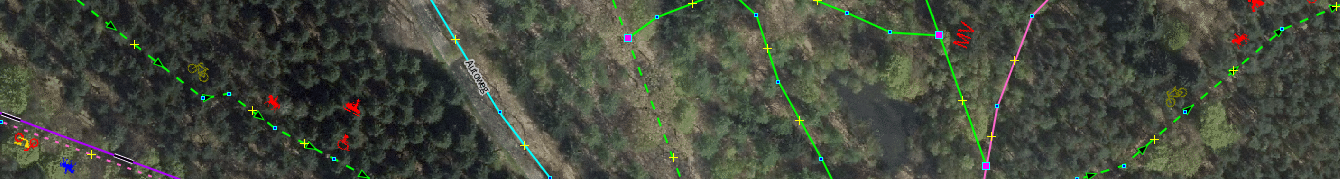
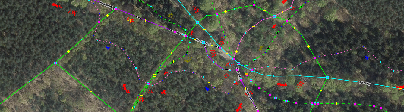
| yes | Lime | #00ff00 |
The public has an official, legally-enshrined right of access; i.e., it's a right of way. | |
| no | Red | #ff0000 |
No access for the general public. | |
| private | Maroon | #800000 |
Only with permission of the owner on an individual basis. | |
| permissive | Orange | #ff6600 |
Open to general traffic until such time as the owner revokes the permission which they are legally allowed to do at any time in the future. | |
| designated | Blue | #0000ff |
A preferred or designated route for the class of traffic specified by the tag key. | |
| destination | Yellow | #ffff00 |
Only when travelling to this element/area. | |
| delivery | Purple | #800080 |
Only when delivering to the element. | |
| consumers | Fuchsia | #ff00ff |
Only for customers of the element. | |
| use_sidepath | Aqua | #00ffff |
Can only be used in countries with compulsory cycleways and gives access information on parallel roads. | |
| dismount | Green | #008000 |
Permitted for some vehicle (or animal) only if you dismount. | |
| agricultural | Brown | #a05a2c |
Only for agricultural traffic. | |
| forestry | Teal | #008080 |
Only for forestry traffic. | |
| discouraged | Grey50 | #808080 |
A legal right of way exists (see yes) but usage is officially discouraged. | |
| official | Olive | #808000 |
The value official for the access tags foot, bicycle and horse indicates a way legally dedicated to specific modes of travel by a law or by the rules of traffic. | |
| limited | access colors | access colors | Wheelchairs have partial access (e.g some areas can be accessed and others not, areas requiring assistance by someone pushing up a steep gradient). |
| Icon | Key | Color | Description | Explanation |
|---|---|---|---|---|
| value set in | white | Mode | This icon have no value. | |
| *:forward=* | access colors | Forward | Forward describe a direction along a way, forward means the direction in which the way is drawn in OpenStreetMap. | |
| *:backward=* | access colors | Backward | Backward describe a direction along a way, backward means the opposite direction in which the way is drawn in OpenStreetMap. | |
| oneway:*=* | access colors | Both directions | Both direction along a way, the drawn and the opposite direction in which the way is drawn in OpenStreetMap. | |
| oneway:*=no | red (no) / lime (yes) | Oneway:(mode)=* | Oneway can be used in conjunction with vehicle type in order to tag exceptions, i.e. oneway:moped=no for a one-way streets, where mopeds are allowed to drive in the opposite direction. |
| Icon | Key/Value | Color | Description | Explanation |
|---|---|---|---|---|
| value set in | white | Mode | This icon have no value. | |
| @ | black/grey | With @ | @ is used in the value | |
| *:conditional=* | access colors | Conditional | Conditional is used in the key. | |
| *:conditional=* | black/grey | Conditional | Conditional is used in the key. | |
| sunrise-sunset | access colors | Daytime | Colored in from sunrise till sunset. | |
| sunset-sunrise | access colors | Nighttime | Colored in from sunset till sunrise. | |
| opening_hours=* | no colors | Opening hours | Opening hours is set on way or node. |

| Item | String | Color | Casing color | Description | Explanation |
|---|---|---|---|---|---|
| *=motorroad | #3377ff | Motorroad | |||
| *=motorway | #809bc0 | Motorway | Also for *=motorway_link | ||
| *=trunk | #7fc97f | Trunk | Also for *=trunk_link | ||
| *=primary | #fb805f | Trunk | Also for *=primary_link | ||
| *=secondary | #ff9900 | Secondary | Also for *=secondary_link | ||
| *=tertiary | #669900 | Tertiary | Also for *=tertiary_link | ||
| *=unclassified | #00ffff | Unclassified | |||
| *=residential | #ffff00 | Residential | |||
| *=living_street | #999999 | #ffffff | living_street | ||
| *=service | #008080 | Service | |||
| *=escape | #c0c0c0 | Escape | |||
| *=road | #770000 | #ff9696 | Road | Please, give the road a indentification. | |
| *=construction | #770000 | #ffff00 | Construction | Map and tag when construction start. | |
| *=track | #ff66cc | Track | tracktype=* 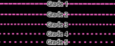 |
||
| *=cycleway | #b100ff | Cycleway | |||
| *=footway | #00ff00 | Footway | |||
| footway=sidewalk | #808080 | Sidewalk | Footway, what is a sidewalk. NL: Trottoir | ||
| *=pedestrian | #999999 | #00ff00 | Pedestrian | ||
| *=path | #00ff00 | Path | |||
| *=bridleway | #a18559 | #ffffff | Bridleway | ||
| *=steps | #ff0000 | Steps | |||
| *=bus_guideway | #404040 | #008080 | Bus guideway | ||
| *=busway | #404040 | #ff0000 | Busway | ||
| *=raceway | #ff80ff | #ffffff | Raceway |
| Item | String | Color | Shape | Description | Explanation |
|---|---|---|---|---|---|
| tracktype=grade1 | #ff66cc | Number | Grade 1 | On highway=track, grade1 number to support the dashed line, on other ways, it could be a wrong tag. | |
| tracktype=grade2 | #ff66cc | Number | Grade 2 | On highway=track, grade2 number to support the dashed line, on other ways, it could be a wrong tag. | |
| tracktype=grade3 | #ff66cc | Number | Grade 3 | On highway=track, grade3 number to support the dashed line, on other ways, it could be a wrong tag. | |
| tracktype=grade4 | #ff66cc | Number | Grade 4 | On highway=track, grade4 number to support the dashed line, on other ways, it could be a wrong tag. | |
| tracktype=grade5 | #ff66cc | Number | Grade 5 | On highway=track, grade5 number to support the dashed line, on other ways, it could be a wrong tag. |
| Item | String | Color | Casing color | Description | Explanation |
|---|---|---|---|---|---|
| *=asphalt | #000000 | #ffffff | Asphalt | ||
| *=concrete | #ffffff | #ffffff | Concrete | One lane, also small for single_tracked vehicle. | |
| *=concrete:lanes | #ffffff | #ffffff | Concrete lanes | Long, narrow concrete plates laid out for a double_tracked vehicle. | |
| *=concrete:plates | #ffffff | #ffffff | Concrete plates | Heavy duty plates chained closely together on the short side. Might have tar or sand in between the connections. | |
| *=paving_stones | #b35900 | #ffffff | Paving stones |
| Item | String | Color | Shape | Description | Explanation |
|---|---|---|---|---|---|
| *=excellent | #000000 | 3 rounds | Excellent | (thin_rollers) roller blade, skate board and all below. | |
| *=good | #000000 | 2 rounds | Good | (thin_wheels) racing bike and all below. | |
| *=intermediate | #000000 | 1 round | Intermediate | (wheels) city bike, sport cars, wheel chair, Scooter and all below. | |
| *=bad | #ff6600 | 1 triangle | Bad | (robust_wheels) trekking bike, normal cars, Rickshaw and all below. | |
| *=very_bad | #ff6600 | 2 triangles | Very bad | (high_clearance) Car with high clearance, light-duty off road vehicles(off_road_wheels) heavy-duty off road vehicles and all below. | |
| *=horrible | #ff6600 | 3 triangles | Horrible | (off_road_wheels) heavy-duty off road vehicles and all below | |
| *=very_horrible | #ff6600 | 4 triangles | Very horrible | (specialized_off_road_wheels) tractor, ATV, tanks, trial, Mountain bike and all kind of off-highway vehicles. | |
| *=impassable | #ff0000 | 1 square | Impassable | No wheeled vehicle. |
| Item | String | Value | Color | Description | Explanation |
|---|---|---|---|---|---|
| maxspeed=* | (number) | #ffff00 | Maxspeed | Maxspeed is set on the highway. | |
| segregated=yes | yes | #00ff00 | Segregated | Used to show that there is some form of segregation between pedestrians and cyclists on a cycle path or footway. NL: Gescheiden wandel en fietsstrook | |
| segregated=no | no | #ff0000 | Segregated | Used to show that a highway=cycleway or highway=footway is shared between cyclists and pedestrians with no line or other separation. |
| Item | String | Shape | Color | Description | Explanation |
|---|---|---|---|---|---|
| type=route | Dot | #ffff00 | All routes | All route relations for foot, bicycle, horse, etc. |
| Item | String | Color | Description | Explanation |
|---|---|---|---|---|
| way > node | #0000ff | Highlight | Highlighted the node of a highway. | |
| way > node:connection | #ff00ff | Connection | Highwaysegment is connected to all kinds of waysegments. This also could be a highway connected to landuse, what is wrong. | |
| way > node:tagged | #ffa500 | Tagged | On the highwaynode is a key/value tagged. Not visible then you see a other icon. | |
| way > node:selected | #ff0000 | Selected | The highwaynode is selected, you can change the key/value or move the node. |
| Item | Visual | Color | Description | Explanation |
|---|---|---|---|---|
| Sign and signals | Traffic signs/signals | Direction can be set on signs and signals. | ||
| Arrow | Black | Direction | The arrow shows the drawn way direction of the OSM way. But NOT when the tag is set on a connection node. Make a new node on the way! Otherwise forward/backward have no meaning. | |
| >? | White/black | No direction | There is not a direction key tagged. Please, tag the direction! | |
| ↓↑ | White/black | Directions | The direction key is tagged. Any value is possible. | |
| ↑ | White/black | Forward | The sign/signal is effective in the forward direction, the OSM drawn way direction. | |
| ↓ | White/black | Backward | The sign/signal is effective in the backward direction, the opposite direction as the drawn OSM way. |
| Icon | Key/Value | Description | Explanation |
|---|---|---|---|
| barrier=bollard | Bollard | One ore more solid (usually concrete or metal) pillar(s) in the middle of the road to prevent passage by some traffic. | |
| barrier=cycle_barrier | Cyclebarrier | A barriers along a path that slows or prevents access for bicycle users. | |
| barrier=kissing_gate | Kissinggate | A type of gate where you have to go into an enclosure and open a gate to get through. | |
| barrier=cattle_grid | Cattlegrid | A hole in the road surface covered in a series of bars that allow wheeled vehicles but not animals to cross. | |
| barrier=turnstile | Turnstile | A passage on foot through a fence. | |
| barrier=full-height_turnstile | Full-height turnstile | A full-height turnstile. | |
| barrier=entrance | Entrance | An opening or gap in a barrier. | |
| barrier=block | Block | One or more large immobile block(s) barring free access along a way. | |
| barrier=stile | Stile | A structure which provides people a passage through or over a boundary via steps, ladders or narrow gaps. | |
| barrier=horse_stile | Horsestile | A horse stile allows pedestrians and horses to cross a gap through a fence. | |
| barrier=sump_buster | Sumpbuster | A barrier to stop cars (two tracked vehicles with less than a certain ground clearance and width between tracks). | |
| barrier=bus_trap | Bus trap | A short section of the roadway where there is a deep dip in the middle to prevent passage by some traffic. | |
| barrier=gate | Gate | A section in a wall or fence which can be opened to allow access. | |
| barrier=hampshire_gate | Hampshiregate | A section in a wall or fence which can be opened to allow access. | |
| barrier=bump_gate | Bumpgate | A drive-through gate used in rural areas to provide a barrier to livestock that does not require the driver to exit the vehicle. | |
| barrier=sliding_gate | Sliding gate | A gate sliding to the side. | |
| barrier=lift_gate | Liftgate | A bar or pole pivoted in such a way as to allow the boom to block vehicular access through a controlled point. | |
| barrier=toll_booth | Toll booth | A place where a road usage toll or fee is collected. | |
| barrier=border_control | Border control | A control point at an international border between two countries. | |
| barrier=swing_gate | Swinggate | A gate consisting of a bar or pole pivoted in such a way as to allow the boom to block vehicular access through a controlled point. | |
| barrier=chain | Chain | A chain used to prevent motorised vehicles. | |
| barrier=rope | Rope | A flexible barrier made of rope. | |
| barrier=height_restrictor | Height restrictor | A height resctrictor which prevents access of vehicles higher than a set limit. If height is tagged, it is shown with a red number, example 2.2 is in meters. | |
| barrier=motorcycle_barrier | Motorcycle barrier | A barrier along a path preventing access by motorcycles. | |
| barrier=debris | Debris | Debris blocking a road. | |
| barrier=log | Log | A log blocking a road. | |
| barrier=jersey_barrier | Jersey barrier | A barrier made of heavy prefabricated blocks. | |
| barrier=spikes | Spikes | Spikes to prevent drive through. | |
| barrier=sally_port | Sallyport | A secure, controlled entryway to a fortification or prison. | |
| barrier=yes | Yes | Please, replace "yes" by a specific value. | |
| barrier=* | (Else) | Else, barrier tagged but excluded those listed above and kerb. Values can be wrong, a fence, what is wrong on a node and all other not often used values and new values. |